E-BIKES: E-bikes are now allowed on the lower sections of the Raptor Route including Hawk's Glide, Falcon Flow and Kestrel. They are not allowed on Eagle Eye. Shuttles will drop e-bikes at the Hawk's Glide Trail Head.
HOW THE SHUTTLE WORKS: In the spring time this shuttle may share the same van as the Whole Enchilada as they share the same early spring access points. Snow in the upper levels keeps us from going higher. We meet at the Chile Pepper Bike Shop, load your bikes there and you can either ride back to town or you can follow us with your car and leave it at the trailend.
Another option, when we are going higher than UPS, you can book the Whole Enchilada Shuttle and ride from whatever section we are dropping off at for the WE(weather dependent) and then in lieu of riding LPS and Porcupine, you can grab the Raptor Route and then take Sand Flats back to town. If we are dropping off at anything above UPS you won't be able to follow with your vehicle. Eagle Eye trailhead is the highest trail in the Raptor Route System.
DESCRIPTION
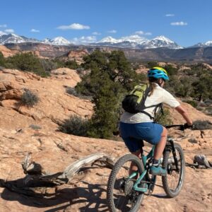
The Raptor Route is a newer downhill-ish point to point trail that parallels Sand Flats Road. It links four trails together, Eagle Eye, Hawk's Glide, Falcon Flow and Kestrel's. This is an intermediate ride and depending on the season can range from 8-30 miles. While there is a lot of flow, there is a lot of pedal too.
This ride is a great stand alone ride or it serves as an alternate exit route for the Whole Enchilada. If you bail on Ole Enchie you would skip LPS and Porcupine, joining Eagle Eye right before LPS starts. The Raptor Route ends on lower Sand Flats Road which leads right into town. This is a great option in the heat of the summer or if you have found the WE to be a little more trail than you bargained for. Or, just a new trail for you to try if you have ridden Porcupine Rim a bunch.
Last week we got the honor of shutting up some shredders from our youth cycling program here in Moab for an after school Kokopelli to raptor route… so Rad!
All the trails are running great right now! Next weekend we should be going up to Kokopelli on the WE, this is the earliest we have gotten this high up:) daily departures to Whole Enchilada, Raptor Route, and magnificent 7. We are also shuttling E-bikes to blm approved trails such as Mag 7 and the Raptor Route
Perfect fall conditions and weather in Moab right now! We will be shuttle to the top of Hazzard this weekend:)unfortunately burro is still a little to muddy and icy from the last storm. Somehow all the snow hitting Colorado missed us. Come get it while it’s still good;)
Whole enchilada is hero conditions right now! We are shuttling to the top and the weather looks perfect for the next two weeks, come ride with us! #wholeenchilada #porcupinerim #coyoteshuttle
To provide the best experiences, we use technologies like cookies to store and/or access device information. Consenting to these technologies will allow us to process data such as browsing behavior or unique IDs on this site. Not consenting or withdrawing consent, may adversely affect certain features and functions.
Functional
Always active
The technical storage or access is strictly necessary for the legitimate purpose of enabling the use of a specific service explicitly requested by the subscriber or user, or for the sole purpose of carrying out the transmission of a communication over an electronic communications network.
Preferences
The technical storage or access is necessary for the legitimate purpose of storing preferences that are not requested by the subscriber or user.
Statistics
The technical storage or access that is used exclusively for statistical purposes.The technical storage or access that is used exclusively for anonymous statistical purposes. Without a subpoena, voluntary compliance on the part of your Internet Service Provider, or additional records from a third party, information stored or retrieved for this purpose alone cannot usually be used to identify you.
Marketing
The technical storage or access is required to create user profiles to send advertising, or to track the user on a website or across several websites for similar marketing purposes.


